
8/26/16 – 9/9/16
145 miles total
Northbound & Southbound

“Does The Walker Choose The Path,
Or The Path The Walker?”
― Garth Nix, Sabriel
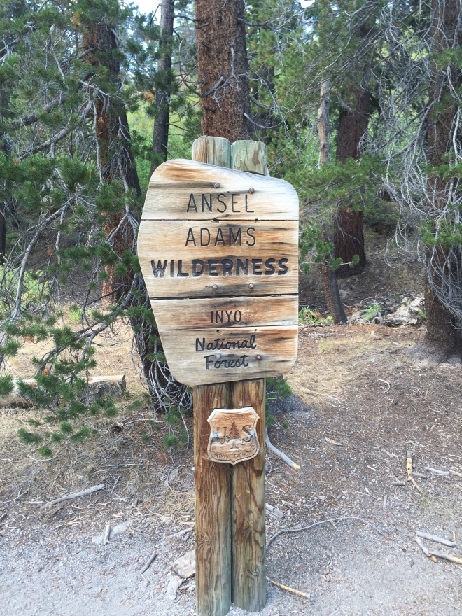
A little more than a year ago, the Rough Fire in Central California raged. We were hiking northbound to Mammoth, but the smoke from the fire, quite a distance from where we were, was so thick we had to go off trail and abort our hike. We exited Taboose Pass, a little-known and infrequently used path off the PCT. A couple of week ago, we picked up from where we left off. But it was a little more complicated than that.
Here is our odd-ball itinerary, in a nutshell, the result of having to get permits:
- Devil’s Post Pile (Mammoth) north to Tuolumne Meadows in Yosemite National Park
- Take bus from Tuolumne back to Mammoth
- Hike from Mammoth southbound to PCT Mile 888 – Ferry to Vermilion Valley Resort (VVR)
- Beer Creek Trail out of VVR to PCT mile 810
- Hike out through Taboose Pass
Logistics were complex. Patti spent a lot of time studying schedules and planning our attack. Because we could not obtain all the needed permits requested, we had to piece-meal our way into compliance. Adding to the challenge was that we wanted to arrive two days earlier than our permits allowed. We were taking a risk to show up early needing to modify our plans. If that were not enough, the permits we needed came from different entities – one from Inyo National Forest, the other from The National Parks System. There were also bus schedules we needed to be aware of – the bus out of Tuolumne, for instance, left at 4:15 PM, which ended up being a big deal, as you will see below. And for the first time we sent a resupply box ahead and we also resupplied in Mammoth.
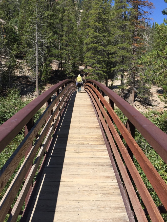
This was our longest hike, both in miles and days. We wound through beautiful meadows and forests and saw the alpine lakes of the High Sierra. There were a lot of rocks, and that sucked. It was dry and windy, but awesome and with gorgeous views. It’s hard to encapsulate all the unique experiences we had in just a few words. Each day was different. Our hike was truly different than any other we’ve done.
We started off slow – ten miles a day on average. We met up with a lot of other hikers and leap-frogged a handful of them several times. We are pretty sure it was noted by the others that we are the slowest hikers on trail. But we were steady, endured longer and usually ended up catching up by day’s end. Going slower, as frustrated as we may have felt at times, meant less joint aches and sore feet. We were much less concerned with water and carried a lot less than on any other hike.
We drove into Mammoth the night before. We needed to get to the ranger station for the permits as early as possible the next morning. Luckily, were able to easily change our itinerary. The only problem was that we couldn’t get a permit to do the hike in one continuous string: we would instead need to first hike 34 miles north to Tuolumne and then bus back to Mammoth to finish our hike traveling south.There are lockers at the Mammoth Mountain Inn near Devil’s Post Pile to store any food that would otherwise be in our car. We could park there. We went to the resort, parked our car and placed the larger bear vault full of food into a locker, and took the smaller vault with us for the three days we would be out for the Tuolumne segment of our hike. We planned ahead in the event we needed to break up our route. With this plan, we used Mammoth as a resupply spot. We were advised to not keep items with odors in the car. Bears break into cars for the smallest of morsels, even a stick of gum. For $5, the locker was a low-cost insurance policy the car wouldn’t be broken into. After getting everything locked away, we caught the Red Meadows bus at the Inn and rode down to Devil’s Post Pile, about a 15-minute ride. Then, we were off to the PCT trailhead going north.
Despite the late start, we got close to 11 miles in. The trail was relatively easy until the last five miles. We climbed roughly 2000 feet to 9500 feet elevation. The next day wasn’t too bad either. Up approximately another 1000 feet. Towards the end of the day though, we were facing our first big challenge: Donahue Pass. We hiked late into the afternoon but ended two miles short of the peak. Those miles appeared straight up. We “passed on the pass,” and camped below.
The third day, a Monday, we were to exit Yosemite National Park before end of day. We both chuckled throughout the hike about how stupid the trail makes us feel sometimes. We cannot manage math. One of us might start thinking about where we are and start spewing out numbers. Like, well, if we hike for two more hours and we’ve done eight miles today so far, and we go 2.5-miles per hour…that makes it 15 miles and we’ll be there in 20 minutes…” Stuff that isn’t right or make sense.
We constantly misjudge our distances and speeds. Donohue Pass was harder than we figured; the down was steeper and harder than planned. Fortunately the last nine miles were flat. We made great time but it was at the expense of not enjoying the alpine lakes and stunning beauty of that area.

We had plans to get a bus from Tuolumne back to Mammoth. We needed to hustle to make the 4:15 pm departure. As usual, our eye for hiking miles was bigger than our stomach to complete them and we barely made the bus. In a very typical show of hiking unity and camaraderie, a hiker we saw earlier in and who had completed his day, saw us searching around the parking lot for the bus stop and he generously gave us a ride to the stop which ended up being more than a mile away. Without his help, we would have never made it.
After a 90-minute bus ride south, we were back at Mammoth Lodge. We enjoyed a terrific hot meal and a beer at the Yodel Bar & Grill right there. The building with lockers across the street was still opened. We assumed it was open 24/7 but it locks up around 8:30. We were still at our locker picking up our bigger bear vault, cleaning up and prepping for the next few days when the guard came in. He let us stay and finish. Five minutes later, we walked out with the door closing and locking behind us. Thirty minutes later, we were pitching our tent at the Minaret Falls hikers campground. We went right to sleep. The next day would be a big one. We would be beginning our hike south to Taboose Pass.
As section hikers, we have never re-supplied during the hikes, opting instead to carry everything from the start. On this trip, we were able to plan a resupply at Vermilion Valley Resort (VVR). Close to PCT mile 880 there is a trail leading to Edison Lake. There, a hiker can catch a ferry across the lake to VVR. A hiker haven, VVR provides showers and rooms, if you want, but you can also camp for free. There is a small grocery store. They accept resupply boxes for $25 per box for handling. Best of all the restaurant is quite good. We hadn’t planned on staying an entire day, let alone over night. We were, nonetheless, lured into the VVR magic when we readily accepted our host’s invitation to have any first drink of our choice on them – including beer! Once we relaxed with a beer and then ate a great burger (grilled cheese for Patti) for lunch we were sucked into taking our first-ever zero-day.

On the ferry to Vermilion Valley Resort
The following day, we hiked along an alternate route to the PCT, the Bear Creek Trail. This was about 10-miles, four or so more than the ferry back and then directly to the PCT: but it was less strenuous and had more water along the way. We were glad we did, given the great landscape of the river valley.
We climbed Donohue Pass on the way north to Tuolumne. Along our southbound travels, we also climbed Silver, Selden, Muir and Mather Passes, the last of which was incredibly difficult.
Last year, when we were exiting our hike at Taboose, we needed to find a way from the trail head at the bottom of the pass into town at Independence. It’s via a painful 10 mile dirt road out to Highway 395. We lucked out when a researcher we met the day before was able to secure a ride for us through one of his colleagues. This year, similarly challenged, we weren’t sure how we were going to finagle this, but figured out something would work out. As luck would have it, while collecting some water before we trekked down the long and rocky decent of Taboose Pass, we met Laurel, a woman solo-hiker. We asked how she was going to get to town once at the bottom, she said she was getting picked up by her husband at the bottom. “Why,” she asked. “you guys need a ride?”
Details of our hike and stories from the trail to follow in the next post.

Sounds and looks like a wonderful journey!
LikeLike
Hi, Ed. Thanks for your comment and for following along. Be sure to check back when we post Part 2, about the people we met on this trip. There was an amazing twist of events that drew things all together. Hope you and the family are all well.
LikeLike
That first photo transported me straight back to the trail. I just melted as I stared at it! Glad you two were able to patch up this section (a favorite of mine!) and I’m looking forward to the next one. Keep them coming!
LikeLike
Thanks, Kate. Nice to hear from you.I think this is now my favorite segment, too. Walking the JMT portion of the trail was amazing. Muir Pass hut was like walking into a church – I felt we were walking on hallowed ground. Lynn
LikeLike
Pingback: Devil’s Post Pile (DPP) to Tuolumne Meadows, DDP to Taboose Pass – Part 2: Connections – McShap Pacific Crest Trail Journal